MINDUNGSAN Place Branding
Mindungsan Mountain Place-Making & Place-Branding Project
Mindungsan Mountain Place-Making & Place-Branding Project
하늘웅덩이 억새평원
민둥산은 강원도 정선군 남면과 동면에 걸쳐 있는 해발 1,124m의 산이다. 산 이름처럼 정상에는 나무가 없으며, 과거 화전민들이 해마다 불을 놓고 경작하던 땅이 화전이 금지된 이후 참억새 숲으로 변해 오늘의 억새평원을 이루었다. 해발 800m의 발구덕 마을에서 남쪽 7부 능선을 따라 정상까지 억새풀이 이어지며, 가을이면 능선이 은빛으로 출렁인다. 민둥산은 얕은 바다에서 퇴적된 석회암 지층이 빗물에 녹아 형성된 돌리네(Doline) 로, 표면이 웅덩이처럼 들어간 카르스트 지형의 대표적 형태를 보여준다. 가파른 경사를 지나 정상에 오르면, 끝없이 펼쳐진 억새 군락과 굴곡진 돌리네 지형이 어우러진 풍경이 이곳을 찾는 이들에게 깊은 인상을 남긴다.
본 프로젝트는 이러한 지형과 자연의 결을 공간 언어로 재해석하여, 민둥산을 단순한 등산지가 아닌 ‘자연의 기억을 경험하는 장소 브랜드’ 로 구축하고자 했다.
민둥산의 선 - 지형에서 비로된 조형 구조
민둥산은 선으로 이루어진 산이다. 계곡을 따라 흐르는 땅선(地線) 과 능선을 따라 이어지는 산선(山線) 은 공간의 리듬이자 디자인을 연결하는 축이 된다. 이 지형의 선에서 파생된 기본 조형 구조는 사인과 조형물 등 주요 공간 요소의 비례와 방향을 결정하며, 민둥산을 구성하는 계곡과 산의 지문(地紋) 을 공간 질서로 전환한다. 이 구조는 자연의 흐름이 공간의 구조로 이어지는 통합 환경디자인 체계를 형성한다.
위치 : 대한민국 강원특별자치도 정선군 남면·동면 일원
좌표 : 37°17′N, 128°50′E / 해발고도 : 1,124 m
지형특성 : 돌리네(Doline) 가 분포한 카르스트 지형, 철분이 풍부한 붉은 토양
식생특성 : 수목 한계선 위에 형성된 참억새(Miscanthus sinensis) 군락
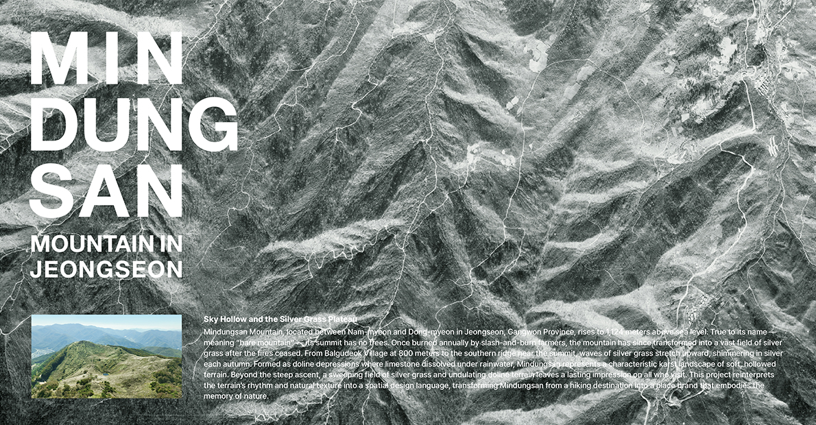
Sky Basin Silver Grass Plains
Mindungsan Mountain sits between Nam-myeon and Dong-myeon in Jeongseon County, Gangwon Special Self-Governing Province, rising to an elevation of 1,124 meters. As its name suggests, the summit is almost entirely treeless. The area was once used as slash-and-burn farmland. After cultivation in this area was prohibited, the land naturally transformed into a vast field of silver grass. From the village of Balgudeok at 800 meters above sea level, silver grass continues up the southern ridgeline to the summit, creating waves of shimmering silver in autumn. Mindungsan Mountain exhibits a classic example of a doline—a karst depression formed as limestone strata deposited in shallow seas were dissolved by rainwater. Upon reaching the top after a steep ascent, visitors are greeted with dramatic views where endless expanses of silver grass blend with the undulating doline terrain. This interplay of ecology and geomorphology leaves a lasting impression on all who visit. This project reinterprets the mountain’s terrain and natural textures into a spatial language, establishing Mindungsan Mountain not merely as a hiking destination but as a place brand where visitors can experience the “memory of nature.”
The Lines of Mindungsan
Mindung Mountain is fundamentally a mountain shaped by lines.The ground lines traced by valleys and the ridge lines that continue along the mountain create a natural rhythm. These lines become a primary design generator. The foundational form structure, derived from these topographic lines, became the framework for the proportion, orientation, and spatial logic of key elements such as signage, sculptural markers, and environmental graphics. The mountain’s geomorphic patterns are translated into spatial order, forming an integrated environmental design system where the natural flow becomes the structural logic of the place.
Location : Nam-myeon & Dong-myeon, Jeongseon, Gangwon Province, Korea
Coordinates : 37°17′N, 128°50′E / Elevation : 1,124 m
Terrain : Karst landscape featuring doline formations and iron-rich reddish soil
Project Type : Place-branding environmental design expressing the land’s lines, textures, and rhythm


Project : Mindungsan Mountain Place-Making & Place-Branding Project
Location : 대한민국 강원특별자치도 정선군 남면·동면 일원
Client : 강원디자인진흥원
Output : 민둥산 장소명소화 디자인 계획 수립
Project Year : 2025
Art director : 안장원 (Ahn Jangwon)
Participating designer : 김대호, 국선영, 유창숙, 금성진, 박소희, 김민지, 강명주


이음파트너스는 ‘공간의 경험 가치를 브랜드화’ 하는 환경•경험디자인 회사입니다. 공간 스토리텔링, 환경그래픽, 웨이파인딩, 색채, 디지털미디어, 영상 등 공간 커뮤니케이션 도구들을 전략적으로 융합하여 이용자에게 색다른 경험 가치(Experiential Value)를 제공합니다.
| To | |
|---|---|
| From | |
| Message |